Metal Detecting Research and Exploration - A Complete Guide, p.6
Map Research for Locating Treasure Hunting Sites in the US
MAP SCALES OF USGS TOPOGRAPHICAL MAPS
(CONTINUED from Page 5)
7.5-Minute Series Maps, Scale 1:31,680
This series was first published in the late 1930s, and used even a larger map-scale - 1:31,680 (one inch representing 1/2 mile, or 1cm = 317 meters). Each 7.5' map is bounded by two meridians and two parallels spaced 7.5 minutes apart. A scale of 1:31,680 allowed considerable detail to be shown in the quadrangle areas.
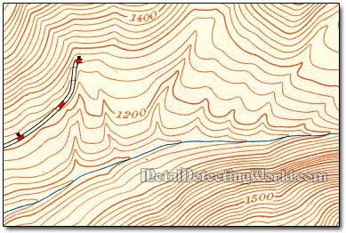
Fragment of 7.5-minute Series Map of 1:31,680 Scale, circa 1947
Those cultural features that had been generalized or omitted on the 15-minute maps were now accurately shown. Because the 7.5-minute map usually has a 10-foot contour interval, the level of detail of the landforms depicted on them is also sharper than on the 15-minute maps. In the early 1950s, two new scales - 1:24,000 and 1:25,000, were adopted for the 7.5-minute series.
7.5-Minute Series Maps, Scales 1:24,000 and 1:25,000
The largest-scale USGS maps are the 1:24,000-scale (1 inch representing 2,000 feet, or 1 centimeter = 240 meters) topographic maps, also known as 7.5-minute quadrangles. Four 7.5-minute sheets replace one 15-minute sheet depicting the same geographic area. Each sheet is 22" x 27" in size and covers 49-70 square miles.
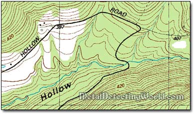
Fragment of 7.5-minute Series Map of 1:25,000 Scale, circa 1964
This series includes almost 200 features separated into color groups for the five color plates: roads shown with casings, buildings, and much of the type - on a black plate; road fills, urban tints, Public Land Survey lines, and other features - on a red plate; woodland tint and other vegetation - on a green plate; hydrographic features - on a blue plate; and contours, depressions, and other hypsographic features - on a brown plate.
This is the only uniform map series that covers the entire area of the United States in considerable detail. A scale of 1:25,000 is used for maps based on metric units (1 centimeter = 0.25 kilometer = 250 meters). The area portrayed on each sheet ranges from 64 square miles at latitude 30 degrees north to 49 square miles at latitude 49 degrees north.
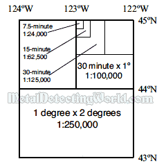
A diagram below shows the relationships between various scales of USGS guadrangles. For instance, each map at a scale of 1:62,500 in older series of maps, 15-minute series, was bounded by two parallels and two meridians spaced 15 minutes apart - the same area covered by four maps in the 7.5-minute series. Similarly, each map at a scale of 1:125,000 in 30-minute series was bounded by two parallels and two meridians spaced 30 minutes apart - the same area covered by four maps in the 15-minute series or by 16 maps in the 7.5-minute series, and so on.
The Nested Scales of Guadrangle Maps Produced by USGS in Relation to Geographic Coordinate System
The old USGS 7.5' quadrangle maps are essential for map research. Full-color copies of topographic map sheets should be used because important details of map features are lost on black and white photocopies. Each sheet of the 7.5-Minute Series is named after the most prominent feature in the quadrangle.
US Geographic names are often rich in description, local color, and national history. Appearing on the old maps, some names such as Pleasant Grove Lane, Smuggler's Pass, Thief Lake, Fun Meadow, Bootlegger Crossing, Treasure Knoll, Hermit's End Road, also might give you some interesting leads for metal detecting research. I have to mention a funny one - A$$awoman (Virginia, US). :) Oh, well, here is another one from the "other side of the pond" - A$$loss (Ayrshire, Scotland). :))))
Ok, here are more real placenames to cheer you up: Findlater (Saskatchewan), Bummers Hill (Hertfordshire, UK), Yorkshire, UK), Balls Falls (Twentymile Creek, Ontario, Canada), Balls Mills (Pennsylvania, US), Balls Green (Kent, England), Bedlam Bottom (Hampshire, UK), Virginville (Pennsylvania, US), Bachelors Bump (Essex, UK), Sober Hill (East Riding, Goose Pimple Junction (VA, USA), Braintree (Boston, MA, USA), Buttzville (PA, USA), Dead Bastard Peak (Wyoming, US), Flat Cat Canyon (San Diego County, California), Devil's Lapful (Northumberland, UK), Dog and Gun (a village in Lancashire, UK), Hopeulikit (Bulloch County, Pennycomequick (Devon, UK), Dollarfields (Clackmananshire, UK), Moneyacres (Ayrshire, Scotland), Peover Heath (Cheshire, UK), Meetoos (Saskatchewan), Eggs and Bacon Bay (Tasmania, Australia), Ham, near Sandwich (Kent, UK), Hornytown (North Carolina, USA), Elephant Butte (New Mexico, USA), Whorehouse Meadows (Oregon, US), Truth or Consequences (New Mexico, US), Maggie's Nipples (Wyoming, US), Sugar Tit (Kentucky, USA), Tittybong (Australia), Great Snoring (Norfolk, UK)...
If you are not familiar with topographic maps, you can skip the pages on Map Research with European Maps (though, lots of useful info is presented there) and read Understanding a Topo Map on page 21.
If you would like to learn Topographic Map Symbols, both old and modern, please go to page 22.
Understanding a map scale of any map is essential for map research. Every map has been drawn to scale, meaning that a certain distance on the map equals a certain distance on the surface of the ground. The Map Scale is usually printed at the BOTTOM of the map. To measure distances between objects and find their true locations, it is important to know how to calculate map scales and convert between different types of them... More details are given on page 26.