Metal Detecting Research and Exploration - A Complete Guide, p.34
Basic Map Analyzing Techniques
MAP COMPARISON - A TUTORIAL
(CONTINUED from Page 33)
My second step is to study the oldest available maps of the area and try to pinpoint the wasted grounds on them. For convenience, I assigned each location a number. At first, it may look confusing to you... Just bear with me.
A Fragment of Historic 1676 Map
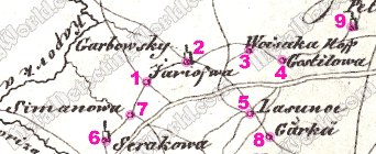
Locations # 1, # 2, # 4, # 5, # 6 and # 7 are villages, and location # 3 is a manor called Woisaka Hoff; hoff (swe.) = manor, estate. Four locations - # 7, # 8, # 9 and # 10, are not the "key-players" in this tutorial and marked just to show you a couple of noticeable changes.
A Fragment of Historic 1704 Map
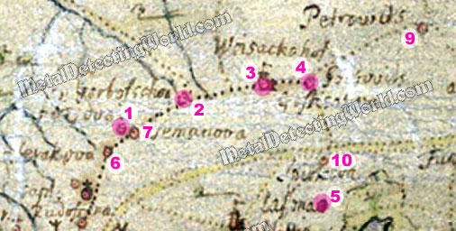
After comparing just these two historic maps, one can see a few changes that had occurred within 30 years between their issuances: settlement # 8 had disappeared from the map, and settlement # 10 appeared on it, a couple of other villages were relocated or merged with other settlements. Also the spellings of place names are slightly different.