Metal Detecting Research and Exploration - A Complete Guide, page 35
Basic Map Analyzing Techniques
MAP COMPARISON - A TUTORIAL
(CONTINUED from Page 34)
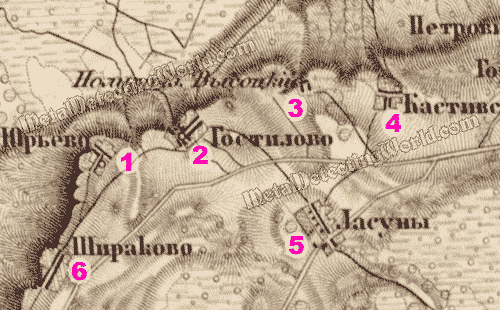
A fragment of the 1850 historic map shown below depicts the area with better accuracy. The scale of this map is "3 verstas to 1 inch." A verst or werst (Russian versta, верста) is an obsolete Russian unit of length. It is defined as being 3500 feet (1.0668 kilometers) long.
A Fragment of Historic 1850 Map of a Scale 1:120,000

Now, new changes can be seen: a village at location # 10 have disappeared, villages at locations # 1 and # 2 were renamed, a village at location # 7 could have either disappeared or merged with a village # 1. A location # 9 was excluded from this map segment due to its distant location.
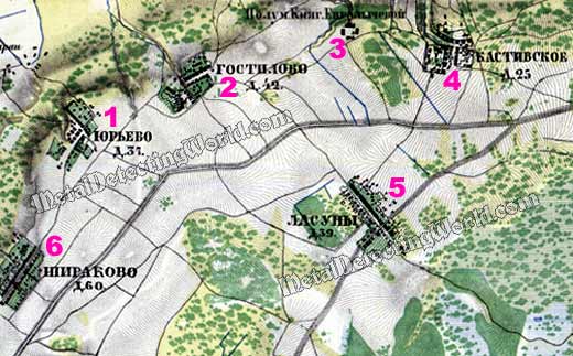
And finally I am using the most accurate and detailed historic map - 1860 Military-Topographic Map of a scale "1 versta to 1 inch" (1:42,000 or 1 cm = 420 m). Comparing this map to a previous one, the only minor changes one can see are the increased sizes of current villages. Both their locations and names have not changed; thus, the map portraits the final phase of changes that had occurred in the area within past 200 years and before a new phase would take place.
A Fragment of Historic 1860 Military-Topographic Map

The map gives me useful information on each settlement, its geographical shape, and number of homesteads in it:
Location # 1 - village of Yurievo (previous names: Fariofwa, Farievo), 37 homesteads;
Location # 2 - village of Gostilovo (previous names: Garbowsky, Gorbofskoi), 42 homesteads;
Location # 3 - manor of Princess Engalycheva (previous names: Woisaka Hoff, Woisacko hof., Vysotskiy manor);
Location # 4 - village of Kastivskoe (previous names: Gostilowa, Gorbovits), 25 homesteads; my full story on metal detecting at this hunt site can be read here.
Location # 5 - village of Lasuny (previous names: Lasunoi, Lasuna), 39 homesteads;
Location # 6 - village of Shirakovo (previous names: Serakowa, Serakova), 60 homesteads; Since this village is still existing, I could figure out where exactly it has decreased in size by using the same Map Overlay method, and easily determine which spots in the village would be available for metal detecting now.